How to Read a Shared River Map for Trade and Everyday Connections
Learn how to read a shared river map to trace crossings, settlements and trade links, and separate visible details from questions that need other sources.
The common mistake with a shared river map is to start by tracing the river line and assume it tells the whole story. That can leave out the roads, crossings and settlements that show how people and goods connect along the water. Read the map for those links, not just the blue line.
You need a regional map with place names, river lines and transport features, plus a pencil or notebook. The aim is to identify visible connections and record what the map cannot settle, rather than to infer how much trade or travel takes place.
Choose the right map
Use an atlas, a library map or a public online map that shows a stretch of river and the places around it. A regional view is often more useful than a close-up: it can show the river alongside roads, railways, ports and settlements. Check the title and legend so you know which features are marked.
Note the map’s coverage. If the river or a route reaches the edge, record that it continues beyond the frame rather than treating the edge as an endpoint. A second map at a different scale can help you see what details are added or omitted.
Trace routes and crossings
Choose a river stretch with named places. Mark settlements beside the channel, then look for bridges, ferries, roads, railways and ports. Record each connection in plain terms: for example, “road crosses near the town” or “rail line follows the river”. These are observations, not evidence of how busy a route is.
Notice whether routes run parallel to the river, cross it, or meet it at a port. A map may show a port symbol without identifying the cargo or the people who use it. Keep visible features separate from questions about activity.
Read the nearby land
Look for mapped farms, industrial areas, markets, forests or protected land. Their proximity to a river can suggest questions about transport and resource use, but it does not establish where water comes from or how a site operates. Record what is marked and leave explanations for sources that address the particular place.
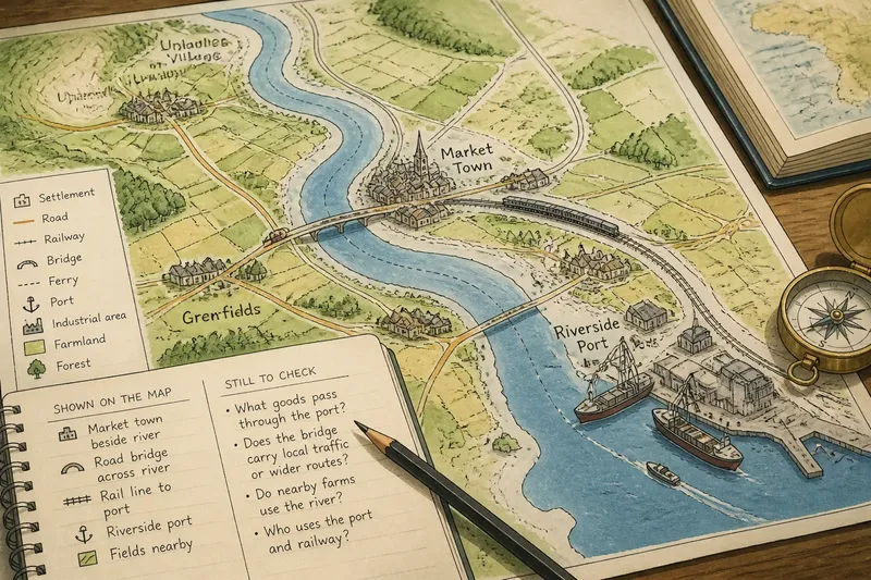
Keep two columns in your notes: “shown on the map” and “still to check”. The first might include a bridge and a market town; the second might ask whether the bridge carries local traffic or whether the port handles agricultural goods. This is a small distinction with a large effect on the accuracy of your account.
Make a connected note
Imagine a map that shows a market town beside a river, a road bridge, a rail line leading towards a port, and fields nearby. Your starting inputs are those four visible features and no information about actual trade. First, list each feature in the “shown” column. Next, draw arrows only where the map shows a route linking them: the road crosses the river, while the rail line reaches the port. Then place questions in the second column: what goods pass through the port, and whether nearby farms use the river. The resulting note describes a possible network of connections without claiming that the map proves any particular cargo or water use.
For another useful check, compare the two banks. Do place names continue on both sides? Is a crossing shown, or does the route disappear at the river? A map can show where a connection appears to exist, but it cannot tell you who can use it or whether it is operating.
Questions about river maps?
What can a river map tell me about trade?
It can show features associated with movement, such as ports, roads, railways and settlements. It usually cannot identify the cargo, volume or commercial arrangements behind those features.
How do I distinguish a fact from an inference?
Describe only what is visibly marked as a map observation, such as a road crossing or a port symbol. Put claims about use, demand or trade in a separate list of questions to check with place-specific sources.
What if a map has no transport symbols?
Record that the map does not show transport routes in the area; do not conclude that none exist. Use a map with transport detail if that connection is central to your question.
Can maps from different sources be compared?
Yes, if you check that they cover the same place and read each legend. Differences can reveal that the maps show different kinds of information, rather than proving that one is wrong.
Check before concluding
Use these checks to decide what the map supports and what needs another source:
Check whether the title covers the whole river stretch you need; if it does, trace the route shown, and if it does not, find a broader map before describing the river’s full connection.
Check the legend for bridge or ferry symbols; if a crossing is marked, record its location, and if not, avoid claiming that no crossing exists.
Check whether a port is labelled; if it is, note the place and its mapped route links, and if it is not, do not infer a port from a riverbank symbol alone.
Check whether roads or railways meet the river; if they do, describe the visible junction or crossing, and if they do not, consult a transport map before making claims about access.
Check whether the map identifies farms or industrial areas; if it does, note their proximity without assigning a water source, and if it does not, leave land use out of the map-based account.
Check whether the map names a cargo or trade activity; if it does, copy the wording and its location, and if it does not, treat cargo as an unanswered question for a local or port-specific source.
A shared river map is most useful when it lets you name a route, a crossing and the places they connect. Keep the distinction between mapped features and human activity visible in your notes; it will make any later account of trade or daily movement more precise.